

Turrach


Slide-Show


.jpg "weather Fürstenfeld (Therme Loipersdorf, Campingplatz Fürstenfeld)")

.jpg "Fürstenfeld (Therme Loipersdorf, Campingplatz Fürstenfeld)")

.jpg "weather Webcam Adelboden (Bernese Oberland)")
.jpg "weather Webcam Florence (Tuscany)")

.jpg "weather Webcam Sylt-Ost (Sylt)")
.jpg "weather Webcam Capoliveri (Elba)")
Quick-Facts
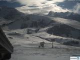
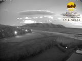
Webcam "Turrach " |
|
|---|---|
| save selected picture | |
| Location of Webcam: | Show on map |
| Webcam-Coordinates: | 46.914444 / 13.875000 |
| Altitude over sea: | 1790m |
| Weather-Webcam-Motiv: | Bergbahnen Turracher Höhe |
| Newest Webcam-Picture: | 28.06.2026 21:30:12 |
| Webcam-Source: | to sourcewebsite |
Infos about Turrach |
|
| Sunrise: | 05:10 hours |
| Sunset: | 21:05 hours |
| Sights in Turrach: |
|
| Famous Waters: | |
| Famous Mountains: | |
| Touristic Regions: |
|
| Wikipedia: | Turrach |
Infos about Turrach
Turrach
In Turrach, there is the Webcam Turrach with motif: Bergbahnen Turracher Höhe.
Enjoy the slideshow of this weather webcam.
The webcam Turrach is regularly updated with new pictures.
Track the current weather in Turrach with the webcam TURRACH.
Weather Webcam Turracherhoehe (Turracherbahn): Track time-lapse weather Webcam live weather Turracherhoehe. Turracherhoehe refers to a village, an alpine pass and a landscape in the Gurktaler Alps in Austria. The homonymous settlement and the Turracher See on the pass are divided by the border between Styria and Carinthia to two federal states. Due to the remote from early settlement areas and high location, the area was settled relatively late. Beginning in the 17th century, mining began below the Turracherhoehe; later, the pass was opened up by a paved road. In the course of the twentieth century, the region was gradually opened up to tourism. The growing biodiversity of plants and animals on the Turracherhoehe one tries to do justice to landscape conservation areas and careful and natural development of tourism facilities.Weather Webcam Turracherhoehe (Turracherbahn): Track time-lapse weather Webcam live weather Turracherhoehe. Turracherhoehe refers to a village, an alpine pass and a landscape in the Gurktaler Alps in Austria. The homonymous settlement and the Turracher See on the pass are divided by the border between Styria and Carinthia to two federal states. Due to the remote from early settlement areas and high location, the area was settled relatively late. Beginning in the 17th century, mining began below the Turracherhoehe; later, the pass was opened up by a paved road. In the course of the twentieth century, the region was gradually opened up to tourism. The growing biodiversity of plants and animals on the Turracherhoehe one tries to do justice to landscape conservation areas and careful and natural development of tourism facilities.
